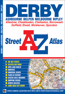
This atlas of Derby, Ashbourne, Belper, Melbourne and Ripley contains 50 pages of coloured street mapping. The continuous coverage around Derby, Belper and Ripley extends to include: *Codnor, Milford, Kilburn, Smalley, Duffield, Little Eaton, Allestree, Mickleover, Chaddesden, Spondon, Ockbrook, Borrowash, Draycott, Etwall, Findern, Sinfin, Chellaston, Ashton-on-Trent and Shardlow. There is separate coverage of both Ashbourne and Melbourne. Also included is a large scale city centre plan of ...
Read More
This atlas of Derby, Ashbourne, Belper, Melbourne and Ripley contains 50 pages of coloured street mapping. The continuous coverage around Derby, Belper and Ripley extends to include: *Codnor, Milford, Kilburn, Smalley, Duffield, Little Eaton, Allestree, Mickleover, Chaddesden, Spondon, Ockbrook, Borrowash, Draycott, Etwall, Findern, Sinfin, Chellaston, Ashton-on-Trent and Shardlow. There is separate coverage of both Ashbourne and Melbourne. Also included is a large scale city centre plan of Derby. Postcode districts, one-way streets and safety camera locations with their maximum speed limit are featured on the street mapping. The index section lists streets, selected flats, walkways and places of interest, junction, place and area names, railway stations, hospitals and hospices covered by this atlas.
Read Less
Add this copy of Derby Street Atlas to cart. $11.00, fair condition, Sold by ThriftBooks-Dallas rated 5.0 out of 5 stars, ships from Dallas, TX, UNITED STATES, published 2012 by Geographers' A-Z Map Company Ltd.