How did intricately detailed sixteenth-century maps reveal the start of the Atlantic World? Beginning around 1500, in the decades following Columbus's voyages, the Atlantic Ocean moved from the periphery to the center on European world maps. This brief but highly significant moment in early modern European history marks not only a paradigm shift in how the world was mapped but also the opening of what historians call the Atlantic World. But how did sixteenth-century chartmakers and mapmakers begin to conceptualize-and ...
Read More
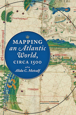
How did intricately detailed sixteenth-century maps reveal the start of the Atlantic World? Beginning around 1500, in the decades following Columbus's voyages, the Atlantic Ocean moved from the periphery to the center on European world maps. This brief but highly significant moment in early modern European history marks not only a paradigm shift in how the world was mapped but also the opening of what historians call the Atlantic World. But how did sixteenth-century chartmakers and mapmakers begin to conceptualize-and present to the public-an interconnected Atlantic World that was open and navigable, in comparison to the mysterious ocean that had blocked off the Western hemisphere before Columbus's exploration? In Mapping an Atlantic World, circa 1500, Alida C. Metcalf argues that the earliest surviving maps from this era, which depict trade, colonization, evangelism, and the movement of peoples, reveal powerful and persuasive arguments about the possibility of an interconnected Atlantic World. Blending scholarship from two fields, historical cartography and Atlantic history, Metcalf explains why Renaissance cosmographers first incorporated sailing charts into their maps and began to reject classical models for mapping the world. Combined with the new placement of the Atlantic, the visual imagery on Atlantic maps-which featured decorative compass roses, animals, landscapes, and native peoples-communicated the accessibility of distant places with valuable commodities. Even though individual maps became outdated quickly, Metcalf reveals, new mapmakers copied their imagery, which then repeated on map after map. Individual maps might fall out of date, be lost, discarded, or forgotten, but their geographic and visual design promoted a new way of seeing the world, with an interconnected Atlantic World at its center. Describing the negotiation that took place between a small cadre of explorers and a wider class of cartographers, chartmakers, cosmographers, and artists, Metcalf shows how exploration informed mapmaking and vice versa. Recognizing early modern cartographers as significant agents in the intellectual history of the Atlantic, Mapping an Atlantic World, circa 1500 includes around 50 beautiful and illuminating historical maps.
Read Less
Add this copy of Mapping an Atlantic World, Circa 1500 to cart. $49.98, like new condition, Sold by GreatBookPrices rated 4.0 out of 5 stars, ships from Columbia, MD, UNITED STATES, published 2020 by Johns Hopkins University Press.
Choose your shipping method in Checkout. Costs may vary based on destination.
Seller's Description:
Fine. Sewn binding. Cloth over boards. 248 p. Contains: Illustrations, color, Halftones, black & white, Line drawings, black & white. In Stock. 100% Money Back Guarantee. Brand New, Perfect Condition, allow 4-14 business days for standard shipping. To Alaska, Hawaii, U.S. protectorate, P.O. box, and APO/FPO addresses allow 4-28 business days for Standard shipping. No expedited shipping. All orders placed with expedited shipping will be cancelled. Over 3, 000, 000 happy customers.
Add this copy of Mapping an Atlantic World, Circa 1500 to cart. $49.99, very good condition, Sold by Tamworth Books rated 5.0 out of 5 stars, ships from San Antonio, TX, UNITED STATES, published 2020 by Johns Hopkins University Press.
Choose your shipping method in Checkout. Costs may vary based on destination.
Seller's Description:
Very good in very good dust jacket. Ships promptly with care via USPS! Inscribed (for Tavis) and signed by the author. No markings or highlights. Jacket and hardcover have very slight wear. Clean, crisp, bright pages. Secure binding. Sewn binding. Cloth over boards. 248 p. Contains: Illustrations, color, Halftones, black & white, Line drawings, black & white. Audience: General/trade; General/trade.
Add this copy of Mapping an Atlantic World, Circa 1500 to cart. $63.46, new condition, Sold by GreatBookPrices rated 4.0 out of 5 stars, ships from Columbia, MD, UNITED STATES, published 2020 by Johns Hopkins University Press.
Choose your shipping method in Checkout. Costs may vary based on destination.
Seller's Description:
New. Sewn binding. Cloth over boards. 248 p. Contains: Illustrations, color, Halftones, black & white, Line drawings, black & white. In Stock. 100% Money Back Guarantee. Brand New, Perfect Condition, allow 4-14 business days for standard shipping. To Alaska, Hawaii, U.S. protectorate, P.O. box, and APO/FPO addresses allow 4-28 business days for Standard shipping. No expedited shipping. All orders placed with expedited shipping will be cancelled. Over 3, 000, 000 happy customers.
Add this copy of Mapping an Atlantic World, Circa 1500 to cart. $63.47, new condition, Sold by Paperbackshop rated 4.0 out of 5 stars, ships from Bensenville, IL, UNITED STATES, published 2020 by Johns Hopkins University Press.