The British Library's map collection is the national cartographic collection of Britain and numbers around four million maps dating from 15 CE to 2017 CE. These include road maps drawn for 13th century pilgrims and sea charts for 17th-century pirates. They include the first printed map to show the Americas and the last to show English-controlled Calais. They include the world's biggest and smallest atlases. They include maps for kings and queens, popes, ministers, schoolchildren, soldiers, tourists. There are maps which ...
Read More
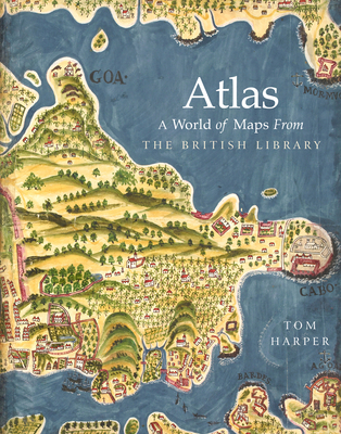
The British Library's map collection is the national cartographic collection of Britain and numbers around four million maps dating from 15 CE to 2017 CE. These include road maps drawn for 13th century pilgrims and sea charts for 17th-century pirates. They include the first printed map to show the Americas and the last to show English-controlled Calais. They include the world's biggest and smallest atlases. They include maps for kings and queens, popes, ministers, schoolchildren, soldiers, tourists. There are maps which changed the world. As well as comprehensively showcasing the varied and surprising treasures of the British Library's "banquet of maps" for the first time, this book will examine the evolution of humanity's perceptions of the world through maps. By looking at how this map collection was assembled principally over two and a half centuries but in reality over a millennium, the book comprises a cartographic history of the world, as well as vivid celebration of the world's best map collection's best maps.
Read Less
Add this copy of Atlas: a World of Maps From the British Library to cart. $32.95, very good condition, Sold by Wide World Maps & More rated 3.0 out of 5 stars, ships from Phoenix, AZ, UNITED STATES, published 2018 by British Library Publishing.
Add this copy of Atlas to cart. $34.59, like new condition, Sold by Paperbackshop rated 4.0 out of 5 stars, ships from Bensenville, IL, UNITED STATES, published 2018 by British Library Publishing.
Choose your shipping method in Checkout. Costs may vary based on destination.
Seller's Description:
Fine. Used-Like New Book. Shipped from UK in 4 to 14 days. Established seller since 2000. Please note we cannot offer an expedited shipping service from the UK.
Add this copy of Atlas: a World of Maps From the British Library to cart. $34.70, good condition, Sold by Zoom Books Company rated 4.0 out of 5 stars, ships from Lynden, WA, UNITED STATES, published 2018 by British Library Publishing.
Choose your shipping method in Checkout. Costs may vary based on destination.
Seller's Description:
Book is in good condition and may contain underlining or highlighting and minimal wear. The book can also include library labels. May not contain miscellaneous items (toys, dvds, etc). We offer 100% money back guarantee and fast customer support.
Add this copy of Atlas: a World of Maps From the British Library to cart. $61.54, very good condition, Sold by Ebooksweb rated 3.0 out of 5 stars, ships from Bensalem, PA, UNITED STATES, published 2018 by British Library Publishing.
Add this copy of Atlas: a World of Maps From the British Library to cart. $62.92, like new condition, Sold by Ebooksweb rated 3.0 out of 5 stars, ships from Bensalem, PA, UNITED STATES, published 2018 by British Library Publishing.
Add this copy of Atlas: a World of Maps From the British Library to cart. $65.00, new condition, Sold by Ebooksweb rated 3.0 out of 5 stars, ships from Bensalem, PA, UNITED STATES, published 2018 by British Library Publishing.
Add this copy of Atlas: a World of Maps From the British Library to cart. $95.92, good condition, Sold by Bonita rated 4.0 out of 5 stars, ships from Newport Coast, CA, UNITED STATES, published 2019 by British Library Publishing.
Add this copy of Atlas: a World of Maps From the British Library to cart. $158.10, new condition, Sold by Bonita rated 4.0 out of 5 stars, ships from Newport Coast, CA, UNITED STATES, published 2019 by British Library Publishing.