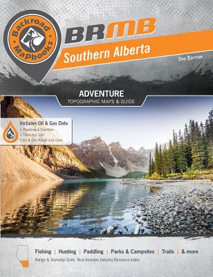
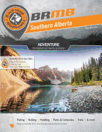
This backroad mapbook is a comprehensive outdoor recreation guidebook for the southern area of Alberta, from just west of the BC-Alberta border to the Alberta-Saskatchewan border and from the US-Canada border to just south of Red Deer. It includes 59 full-page detailed colour recreational GPS-compatible topographical relief maps. The book provides information on trip planning, backroad and park adventures, fishing, hunting, camping, hiking, paddling, wildlife viewing, winter activities, and more. It includes Brooks, Calgary ...
Read More
This backroad mapbook is a comprehensive outdoor recreation guidebook for the southern area of Alberta, from just west of the BC-Alberta border to the Alberta-Saskatchewan border and from the US-Canada border to just south of Red Deer. It includes 59 full-page detailed colour recreational GPS-compatible topographical relief maps. The book provides information on trip planning, backroad and park adventures, fishing, hunting, camping, hiking, paddling, wildlife viewing, winter activities, and more. It includes Brooks, Calgary, Canmore, Crowsnest Pass, Cypress Hills Park, Drumheller, Fort McLeod, High River, Kananaskis Country, Lethbridge, Medicine Hat, and Waterton Park.
Read Less
Add this copy of Southern Alberta Backroad Mapbook to cart. $81.59, good condition, Sold by Bonita rated 4.0 out of 5 stars, ships from Newport Coast, CA, UNITED STATES, published 2012 by Mussio Ventures.
Add this copy of Southern Alberta Backroad Mapbook to cart. $114.31, new condition, Sold by Just one more Chapter, ships from Miramar, FL, UNITED STATES, published 2012 by Mussio Ventures.
Add this copy of Southern Alberta Backroad Mapbook to cart. $119.32, new condition, Sold by Bonita rated 4.0 out of 5 stars, ships from Newport Coast, CA, UNITED STATES, published 2012 by Mussio Ventures.