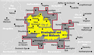
A regional street atlas for Birmingham and the West Midlands. The colour mapping is prepared by the Ordnance Survey and offers coverage of all urban and rural areas. The mapping is at the standard scale of 3.5 inches to one mile and is complete with postcode boundaries on the maps.
Read More
A regional street atlas for Birmingham and the West Midlands. The colour mapping is prepared by the Ordnance Survey and offers coverage of all urban and rural areas. The mapping is at the standard scale of 3.5 inches to one mile and is complete with postcode boundaries on the maps.
Read Less
Add this copy of Birmingham and West Midlands Street Atlas to cart. $57.11, good condition, Sold by Bonita rated 4.0 out of 5 stars, ships from Newport Coast, CA, UNITED STATES, published 1998 by Survey.