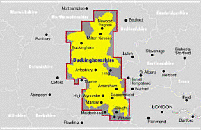
An atlas suitable for business and leisure, this Ordnance Survey street map has coverage of all rural and urban areas in Buckinghamshire. School locations, emergency services, hospitals, police stations, car parks, rail and bus station locations are also included. The scale is 3.5 inches to 1 mile.
Read More
An atlas suitable for business and leisure, this Ordnance Survey street map has coverage of all rural and urban areas in Buckinghamshire. School locations, emergency services, hospitals, police stations, car parks, rail and bus station locations are also included. The scale is 3.5 inches to 1 mile.
Read Less
Add this copy of Bucks Street Atlas: Complete County, Wide Coverage: to cart. $40.94, good condition, Sold by Bonita rated 4.0 out of 5 stars, ships from Newport Coast, CA, UNITED STATES, published 1997 by Ordnance Survey.