-
1. Marchionatus Moraviae Circulus Brunnensis Quem Mandato Caesareo
by Homann, Johann Baptist
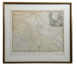
Seller Description: Map. A map of the Moravia area of what is now the Czech Republic. The map was created by German geographer Johann Baptist Homann and dates to roughly 1720. It is in Very Good condition and has hand-colored details empasizing the borders. The map is matted and in a wooden frame. The frame is damaged on the left side and the backing is torn along edges. The map measures 24" x 20" and the frame measures 31.75" x 28.75". AT consignment. Shelved Rockville upstairs. 1375291. Arts & Antiques. See More Details
1720
Rockville, MD, USA
$200.00
-
2. Circuli Brunnensis Pars Meridionalis
by Homann, Johann Baptist

Seller Description: Map. A map of Moravia, the eastern region of the current Czech Republic. The map is centered on the city of Brno. The legend is contained within a vignette of a stag hunt. It was created by Johann Baptist Homann and is from 1716. In Very Good condition with light age toning to map edges and hand-colored details detailing borders and area of Moravia. The map is housed in a metal frame. The map measures 24" x 20" and the frame measures 32" x 28.75". AT Consignment. Shelved Rockville upstairs. ... See More Details
1716
Rockville, MD, USA
$200.00
-
3. Totius Regni Galliae Sive Franciae Tabula
by Homann, Johann Baptist

Seller Description: Map. Engraving with hand coloring. Image measures 19 1/8" x 22 1/2". This exquisite map depicts the entirety of France and a small portion of the southern British Isles. Published circa 1730, the map is extremely detailed with fortified cities, towns, roads, rivers, mountains, and more. To the far left is a dramatic black-and-white cartouche which includes portrait of King Louis XV and images of Neptune and Mercury. In addition, there are 12 coats of arms for the regions of France in the upper ... See More Details
Homann, Johann Baptist
unbound, Good
New York, NY, USA
$300.00
-
4. Statuum Marocca Norum
by Homann, Johann Baptist

Seller Description: Map. Engraving with original hand coloring. Image measures 19.5" x 22". Map of Morocco and the Canary Islands. Includes beautiful views of Marrakesh and Meknes and stunning graphic cartouche with merchants and Tanger in the background. Tent cities are shown throughout. Map is in good condition with some light foxing and repair to lower center margin. Johann Baptist Homann (1664-1724) was a renowned German mapmaker of the late 17th and early 18th century, including being geographer to the Holy ... See More Details
1728, Homann, Johann Baptist
unbound, Good
New York, NY, USA
$650.00
-
5. Nova Anglia Septentrionali Americae Implantata Anglorumique Coloniis Florentissima
by Homann, Johann Baptist

Seller Description: Map. Engraving with hand coloring. Image measures 19 1/8" x 22.5". Early map of New England by Johann Baptist Homann dates to circa 1716. Extends from the Delaware Bay to Quebec and the St. Lawrence River and from Philadelphia east to Nova Scotia. Includes New York, New Jersey, all of New England and parts of Pennsylvania and Canada. The map notes American Indian as well as European settlements. Abound with interesting elements, the map is a beautiful example of the many speculations found in ... See More Details
Homann, Johann Baptist
unbound
New York, NY, USA
$1,650.00
-
6. Regni Mexicani Seu Novae Hispaniae, Ludovicianae, N. Angliae, Carolinae, Virginiae Et Pensylvaniae, Necnon Insularum, Archipelagi Mexicani in America Septentrionali
by Homann, Johann Baptist

Seller Description: Map. Copper engraving with original hand coloring. Image measures 18.75" x 22.5". This striking circa 1720 map by Johann Baptist Homann extends from the Great Lakes southward to include Florida, West Indies, Central America, up to Venezuela, and from New Mexico to the eastern seaboard. Based on the 1703 Delisle map of Mexico and Florida, this map includes information from the explorations of La Salle, Bienville, Le Sueur, d'Iberville, Lederer, and other early travelers. The most striking ... See More Details
Homann, Johann Baptist
unbound, Good
New York, NY, USA
$2,250.00
-
7. The Natural History of Norway: Containing, a Particular and Accurate Account of the Temperature of the Air, the Different Soils, Waters, Vegetables, Metals, Minerals, Stones, Beasts, Birds, and Fishes; Together With the Dispositions, Customs, and...
by Pontoppidan, Erich (1698-1764) (Author); Johann Baptist Homann (1664-1724), Cartographer; Niels, Horrebow, (1712-1760),...

Seller Description: Folio. 22 x 35cm. Contemporary calf with spine repaired. Norway: Large folding map 60.5 x 50 cm by Homman with tear at binder's edge and 28 numbered plates....Iceland with folding map 35 x 41cm. as frontispiece...Very good. Provenance: Joh or Foh with gryphon book plate & motto "Sis Fortis"; Charles Delaet, Esq. of Potterells (d.1792) of Lincoln's Inn; Coningsby C. Sibthorp.....OCLC Number / Unique Identifier: 1026710680. Norway: Translated by Andreas Berthelson Translation of Det foÌrste forso ... See More Details
London: (Norway) Printed for A. Linde, Bookseller to Her Royal Highness...
San Francisco, CA, USA
$3,750.00
|
![]()