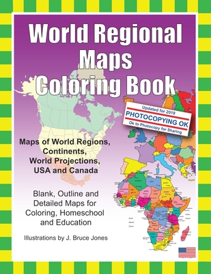
World Regions Coloring Book with blank and outline maps is great for learning world regional geography, coloring, homeschool, and education. Learn and color blank and outline maps of the world and its regions. Each blank, outline, printable continent map is presented with a detailed version with political borders, country, capitals, major city names and country name, and then an outline map with just country names and a blank outline map without any of the information, great to color however you want. Students can trace ...
Read More
World Regions Coloring Book with blank and outline maps is great for learning world regional geography, coloring, homeschool, and education. Learn and color blank and outline maps of the world and its regions. Each blank, outline, printable continent map is presented with a detailed version with political borders, country, capitals, major city names and country name, and then an outline map with just country names and a blank outline map without any of the information, great to color however you want. Students can trace the outlines of the map, study and highlight continents and features on the blank map. A great resource for students and teachers. Black outline blank world maps included in the coloring book are: World Maps - Robinson Projection World Maps - Mercator Projection United States Outline Maps, with and without names Canada Maps, with and without names World Regional and Continent Maps: Africa Map Asia Map Australia, Oceania Map Australia Map Europe Map Maps of North America including Canada, USA and Mexico South America Antarctica Map Additional world regions maps included are: Russia Map Central America and the Caribbean Map Central America Map Europe to the Ural Mountains Map Eastern Europe Map Eastern Europe - Balken Regional Map Middle East Map Mediterranean Regional Map Latin America Map Scandinavia Map Southeast Asia Map Maps come with and in a blank version without names. The printable, blank, outline regional maps in this coloring book can be freely photocopied by a teacher or parent for use in a classroom or for homeschool lessons. World Regional Maps Coloring Book, updated for 2019.
Read Less
Add this copy of World Regional Maps Coloring Book: Maps of World to cart. $8.94, new condition, Sold by Ingram Customer Returns Center rated 5.0 out of 5 stars, ships from NV, USA, published 2011 by Createspace Independent Publishing Platform.
Add this copy of World Regional Maps Coloring Book: Maps of World to cart. $12.98, new condition, Sold by GreatBookPrices rated 4.0 out of 5 stars, ships from Columbia, MD, UNITED STATES, published 2011 by Createspace Independent Publishing Platform.
Choose your shipping method in Checkout. Costs may vary based on destination.
Seller's Description:
New. Trade paperback (US). Glued binding. 92 p. Contains: Illustrations, black & white. In Stock. 100% Money Back Guarantee. Brand New, Perfect Condition, allow 4-14 business days for standard shipping. To Alaska, Hawaii, U.S. protectorate, P.O. box, and APO/FPO addresses allow 4-28 business days for Standard shipping. No expedited shipping. All orders placed with expedited shipping will be cancelled. Over 3, 000, 000 happy customers.
Add this copy of World Regional Maps Coloring Book: Maps of World to cart. $12.99, new condition, Sold by Just one more Chapter, ships from Miramar, FL, UNITED STATES, published 2011 by CreateSpace Independent Publis.
Add this copy of World Regional Maps Coloring Book: Maps of World to cart. $57.46, new condition, Sold by Bonita rated 4.0 out of 5 stars, ships from Newport Coast, CA, UNITED STATES, published 2011 by CreateSpace Independent Publis.