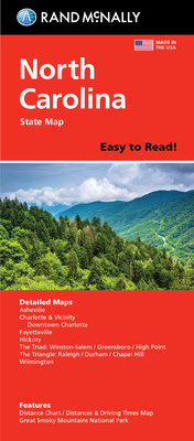
Rand McNally's folded map for North Carolina is a must-have for anyone traveling in or through the state, offering unbeatable accuracy and reliability at a great price. Our trusted cartography shows all Interstate, U.S., state, and county highways and much more. -Points of interest. -State park chart. -State mileage chart. -Driving times map. -On-the-road toolbox. -Visitor center information. -Climate data. -State facts & symbols. -Easy-to-use legend. -Detailed indexed. Coverage Area: Detailed maps include Asheville, ...
Read More
Rand McNally's folded map for North Carolina is a must-have for anyone traveling in or through the state, offering unbeatable accuracy and reliability at a great price. Our trusted cartography shows all Interstate, U.S., state, and county highways and much more. -Points of interest. -State park chart. -State mileage chart. -Driving times map. -On-the-road toolbox. -Visitor center information. -Climate data. -State facts & symbols. -Easy-to-use legend. -Detailed indexed. Coverage Area: Detailed maps include Asheville, Charlotte, Fayetteville, Gastonia, Great Smoky Mountains National Park, Raleigh/Durham/Chapel Hill, Wilmington, Winston-Salem/Greensboro/High Point. Product Details: Measures 9.0 x 4.125 and folds out to 25.5 x 36.75
Read Less
Add this copy of Rand McNally Easy to Read Folded Map: North Carolina to cart. $11.95, new condition, Sold by Wide World Maps & More rated 3.0 out of 5 stars, ships from Phoenix, AZ, UNITED STATES, published 2021 by Rand McNally.