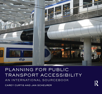
Bringing together a comparative analysis of the accessibility by public transport of 23 cities spanning four continents, this book provides a "hands-on" introduction to the evolution, rationale and effectiveness of a new generation of accessibility planning tools that have emerged since the mid-2000s. The Spatial Network Analysis for Multimodal Urban Transport Systems (SNAMUTS) tool is used as a practical example to demonstrate how city planners can find answers as they seek to improve public transport accessibility. ...
Read More
Bringing together a comparative analysis of the accessibility by public transport of 23 cities spanning four continents, this book provides a "hands-on" introduction to the evolution, rationale and effectiveness of a new generation of accessibility planning tools that have emerged since the mid-2000s. The Spatial Network Analysis for Multimodal Urban Transport Systems (SNAMUTS) tool is used as a practical example to demonstrate how city planners can find answers as they seek to improve public transport accessibility. Uniquely among the new generation of accessibility tools, SNAMUTS has been designed for multi-city comparisons. A range of indicators are employed in each city including: the effectiveness of the public transport network; the relationship between the transport network and land use activity; who gets access within the city; and how resilient the city will be. The cities selected enable a comparison between cities by old world-new world; public transport modes; governance approach; urban development constraints. The book is arranged along six themes that address the different planning challenges cities confront. Richly illustrated with maps and diagrams, this volume acts as a comprehensive sourcebook of accessibility indicators and a snapshot of current policy making around the world in the realm of strategic planning for land use transport integration and the growth of public transport. It provides a deeper understanding of the complexity, opportunities and challenges of twenty-first-century accessibility planning.
Read Less
Add this copy of Planning for Public Transport Accessibility: An to cart. $68.12, new condition, Sold by Booksplease rated 4.0 out of 5 stars, ships from Southport, MERSEYSIDE, UNITED KINGDOM, published 2020 by Routledge.
Add this copy of Planning for Public Transport Accessibility: An to cart. $195.15, like new condition, Sold by GreatBookPrices rated 4.0 out of 5 stars, ships from Columbia, MD, UNITED STATES, published 2016 by Routledge.
Choose your shipping method in Checkout. Costs may vary based on destination.
Seller's Description:
Fine. Intended for college/higher education audience. In Stock. 100% Money Back Guarantee. Brand New, Perfect Condition, allow 4-14 business days for standard shipping. To Alaska, Hawaii, U.S. protectorate, P.O. box, and APO/FPO addresses allow 4-28 business days for Standard shipping. No expedited shipping. All orders placed with expedited shipping will be cancelled. Over 3, 000, 000 happy customers.
Add this copy of Planning for Public Transport Accessibility: an to cart. $195.16, very good condition, Sold by Reuseabook rated 4.0 out of 5 stars, ships from Gloucester, GLOS, UNITED KINGDOM, published 2016 by Routledge.
Choose your shipping method in Checkout. Costs may vary based on destination.
Seller's Description:
Dispatched, from the UK, within 48 hours of ordering. Though second-hand, the book is still in very good shape. Minimal signs of usage may include very minor creasing on the cover or on the spine.