Peddars Way and Norfolk Coast Path: Trailblazer British Walking Guide: Practical Guide to Walking the Whole Path with 55 Large-Scale Maps, Planning, Places to Stay, Places to Eat
Peddars Way and Norfolk Coast Path: Trailblazer British Walking Guide: Practical Guide to Walking the Whole Path with 55 Large-Scale Maps, Planning, Places to Stay, Places to Eat
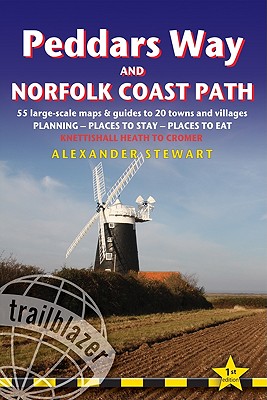
Practical guide to walking the whole Peddars Way and Norfolk Coast Path. The Peddars Way & Norfolk Coast Path is a 93-mile (150km) National Trail that runs from Knettishall Heath Country Park on the Norfolk/Suffolk border in East Anglia, and follows a Roman road to Holme-next-the-Sea and along the beautiful Norfolk coastline through Holkham, Blakeney and Cley to end at Cromer. The guide includes: Peddars Way and Norfolk Coast map, 54 large-scale detailed walking maps (1:20,000), guides to 28 towns and villages. Detailed ...
Read More
Practical guide to walking the whole Peddars Way and Norfolk Coast Path. The Peddars Way & Norfolk Coast Path is a 93-mile (150km) National Trail that runs from Knettishall Heath Country Park on the Norfolk/Suffolk border in East Anglia, and follows a Roman road to Holme-next-the-Sea and along the beautiful Norfolk coastline through Holkham, Blakeney and Cley to end at Cromer. The guide includes: Peddars Way and Norfolk Coast map, 54 large-scale detailed walking maps (1:20,000), guides to 28 towns and villages. Detailed accommodation guide: campsites, B&Bs, hostels, hotels, bunkhouses. Where to eat: cafes, teashops, pubs and restaurants. Detailed public transport information. Itineraries for all walkers including one day Peddars Way and Norfolk Coast Path walks. Downloadable GPS waypoints. Colour pictures including a 6 page colour bird and flower guide.
Read Less
Add this copy of Peddars Way and Norfolk Coast Path to cart. $22.02, good condition, Sold by Anybook rated 4.0 out of 5 stars, ships from Lincoln, UNITED KINGDOM, published 2011 by Trailblazer Publications.
Choose your shipping method in Checkout. Costs may vary based on destination.
Seller's Description:
This is an ex-library book and may have the usual library/used-book markings inside. This book has soft covers. In good all round condition. Please note the Image in this listing is a stock photo and may not match the covers of the actual item, 350grams, ISBN: 9781905864287.
Add this copy of Peddars Way and Norfolk Coast Path: Trailblazer British to cart. $22.51, poor condition, Sold by Anybook rated 4.0 out of 5 stars, ships from Lincoln, UNITED KINGDOM, published 2011 by Trailblazer Publications.
Choose your shipping method in Checkout. Costs may vary based on destination.
Seller's Description:
This is an ex-library book and may have the usual library/used-book markings inside. This book has soft covers. Clean from markings. In poor condition, suitable as a reading copy. Please note the Image in this listing is a stock photo and may not match the covers of the actual item, 350grams, ISBN: 9781905864287.
Add this copy of Peddars Way & Norfolk Coast Path: British Walking Guide to cart. $42.96, good condition, Sold by Bonita rated 4.0 out of 5 stars, ships from Newport Coast, CA, UNITED STATES, published 2011 by Trailblazer Publications.