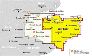
This street atlas includes all rural areas and villages as well as urban districts at a scale of 3.5 inches to 1 mile. Principal routes are colour coded and numbered, and the postcode for every named street is included in the indexes. Hospitals and schools are among the amenities indicated.
Read More
This street atlas includes all rural areas and villages as well as urban districts at a scale of 3.5 inches to 1 mile. Principal routes are colour coded and numbered, and the postcode for every named street is included in the indexes. Hospitals and schools are among the amenities indicated.
Read Less
Add this copy of Celestial Navigation for Yachtsmen to cart. $15.99, good condition, Sold by Brit Books rated 4.0 out of 5 stars, ships from Milton Keynes, BUCKINGHAMSHIRE, UNITED KINGDOM, published 1980 by Stanford Maritime.
Choose your shipping method in Checkout. Costs may vary based on destination.
Seller's Description:
Good. Simply Brit welcome to our online used book store, where affordability meets great quality. Dive into a world of captivating reads without breaking the bank. We take pride in offering a wide selection of used books, from classics to hidden gems, ensuring there's something for every literary palate. All orders are shipped within 24 hours and our lightning fast-delivery within 48 hours coupled with our prompt customer service ensures a smooth journey from ordering to delivery. Discover the joy of reading with us, your trusted source for affordable books that do not compromise on quality.
Add this copy of Ordnance Survey East Kent Street Atlas (Os / Philip's to cart. $16.82, good condition, Sold by Greener Books rated 4.0 out of 5 stars, ships from London, UNITED KINGDOM, published 1997 by Philip's OS Publications.
Choose your shipping method in Checkout. Costs may vary based on destination.
Seller's Description:
Good. **SHIPPED FROM UK** We believe you will be completely satisfied with our quick and reliable service. All orders are dispatched as swiftly as possible! Buy with confidence! Greener Books.