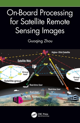
This book explains methods, mathematical models, and key technologies used for on-board processing for remotely sensed satellite images, a technology that maximizes image data transmission efficiency. Intended for students, researchers, and professionals in government and industry interested in the remote sensing of cities and disaster monitoring.
Read More
This book explains methods, mathematical models, and key technologies used for on-board processing for remotely sensed satellite images, a technology that maximizes image data transmission efficiency. Intended for students, researchers, and professionals in government and industry interested in the remote sensing of cities and disaster monitoring.
Read Less