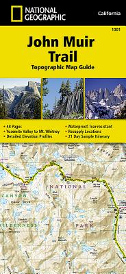
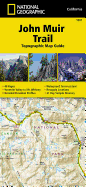
- Waterproof - Tear-Resistant - Topographic Map National Geographic's Map Guide of the John Muir Trail is an indispensable tool for navigating one of the most famous trails in the United States. Expertly researched and created in partnership with local land management agencies, this product provides detailed topographic maps, interesting history, a waypoint table, information about wilderness safety, and key points of interest you will encounter along the trail. A resupply location chart shows shipping address/contact ...
Read More
- Waterproof - Tear-Resistant - Topographic Map National Geographic's Map Guide of the John Muir Trail is an indispensable tool for navigating one of the most famous trails in the United States. Expertly researched and created in partnership with local land management agencies, this product provides detailed topographic maps, interesting history, a waypoint table, information about wilderness safety, and key points of interest you will encounter along the trail. A resupply location chart shows shipping address/contact information, distances, and services available at each resupply point. Each map page has a detailed trail profile that shows the elevation changes you will encounter. Also, the John Muir Trail is highlighted and centered on each page so you can easily track your progress. The maps start at the northern terminus in Yosemite Valley and progress along the ridge of the Sierra Nevada, past Devils Postpile, and end at the highest point in the lower 48 on the top of Mount Whitney. Along the way you will pass through; Yosemite National Park, Ansel Adams Wilderness, Devils Postpile National Monument, John Muir Wilderness, Kings Canyon National Park, and finally, Sequoia National Park and Mount Whitney. A 21-day sample itinerary is included as well. Every Topographic Map Guide is printed on "Backcountry Tough" waterproof, tear-resistant paper. A full UTM grid is printed on the map to aid with GPS navigation. Other features found on this map include: Ansel Adams Wilderness, Bridalveil Fall, El Capitan, Illilouette Falls, Inyo National Forest, John Muir Wilderness, Kings Canyon National Park, Lake Thomas A Edison, Lower Yosemite Fall, Middle Palisade, Mount Agassiz, Mount Darwin, Mount Muir, Mount Pinchot, Mount Powell, Mount Ritter, Mount Russell, Mount Tyndall, Mount Whitney, Mount Williamson, Nevada Fall, North Palisade, Ribbon Fall, Ritter Range, Sequoia National Park, Sierra National Forest, Sierra Nevada, Split Mountain, Upper Yosemite Falls, Vernal Fall, Yosemite National Park, Yosemite Valley. Map Scale = 1:63,360 Folded Size = 4.25" x 9.25"
Read Less
Add this copy of John Muir Trail Topographic Map Guide (National to cart. $10.21, good condition, Sold by HPB Inc. rated 4.0 out of 5 stars, ships from Dallas, TX, UNITED STATES, published 2022 by Natl Geographic Society Maps.
Choose your shipping method in Checkout. Costs may vary based on destination.
Seller's Description:
Good. Connecting readers with great books since 1972! Used books may not include companion materials, and may have some shelf wear or limited writing. We ship orders daily and Customer Service is our top priority!
Add this copy of John Muir Trail Topographic Map Guide (National to cart. $17.95, new condition, Sold by Russell Books rated 4.0 out of 5 stars, ships from Victoria, BC, CANADA, published 2014 by National Geographic Maps.
Add this copy of John Muir Trail Topographic Map Guide to cart. $24.13, new condition, Sold by Ria Christie Books rated 5.0 out of 5 stars, ships from Uxbridge, MIDDLESEX, UNITED KINGDOM, published 2014 by National Geographic Maps.
Add this copy of John Muir Trail Topographic Map Guide: Topographic Map to cart. $25.64, new condition, Sold by Revaluation Books rated 4.0 out of 5 stars, ships from Exeter, DEVON, UNITED KINGDOM, published 2014 by Natl Geographic Maps.
Add this copy of John Muir Trail Topographic Map Guide National to cart. $28.31, new condition, Sold by Paperbackshop rated 4.0 out of 5 stars, ships from Bensenville, IL, UNITED STATES, published 2014 by National Geographic Maps Division.
Add this copy of John Muir Trail (Topographic Map Guide) to cart. $28.88, new condition, Sold by Blackwell's rated 3.0 out of 5 stars, ships from Gloucester, GLOUCESTERSHIRE, UNITED KINGDOM, published 2014 by National Geographic Maps Division.


![Appalachian Trail, Damascus to Bailey Gap [virginia]](https://www3.alibris-static.com/appalachian-trail-damascus-to-bailey-gap-virginia/isbn/9781597756402.gif)
![Appalachian Trail, Springer Mountain to Davenport Gap [georgia, North Carolina, Tennessee]](https://www2.alibris-static.com/appalachian-trail-springer-mountain-to-davenport-gap-georgia-north-carolina-tennessee/isbn/9781597756389.gif)
![Appalachian Trail, Bailey Gap to Calf Mountain [virginia]](https://www0.alibris-static.com/appalachian-trail-bailey-gap-to-calf-mountain-virginia/isbn/9781597756419.gif)
![Appalachian Trail, Davenport Gap to Damascus [north Carolina, Tennessee]](https://www0.alibris-static.com/appalachian-trail-davenport-gap-to-damascus-north-carolina-tennessee/isbn/9781597756396.gif)