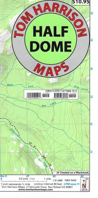
The new Half Dome Trail map in Yosemite National park covers the area between Tenaya Lake and Glacier Point road, centered on the Half Dome. Verna Fall, Nevada Fall, North Dome, Clouds Rest, Tenaya Lake, Glacier Point, Yosemite Creek, Panorama Trail, Little Yosemite Valley & Mono Meadow. Map is at a scale where one inch represents a half-mile. Printed on waterproof & tear resistant plastic.
Read More
The new Half Dome Trail map in Yosemite National park covers the area between Tenaya Lake and Glacier Point road, centered on the Half Dome. Verna Fall, Nevada Fall, North Dome, Clouds Rest, Tenaya Lake, Glacier Point, Yosemite Creek, Panorama Trail, Little Yosemite Valley & Mono Meadow. Map is at a scale where one inch represents a half-mile. Printed on waterproof & tear resistant plastic.
Read Less
Add this copy of Half Dome: Glacier Point, Yosemite Creek, Tenaya Lake, to cart. $33.65, good condition, Sold by Bonita rated 4.0 out of 5 stars, ships from Newport Coast, CA, UNITED STATES, published 2012 by Tom Harrison Maps.
Add this copy of Half Dome: Glacier Point, Yosemite Creek, Tenaya Lake, to cart. $63.47, new condition, Sold by Bonita rated 4.0 out of 5 stars, ships from Newport Coast, CA, UNITED STATES, published 2012 by Tom Harrison Maps.