This street atlas of Dartford, Gravesend, Bexleyheath, Erith, Northfleet, Sidcup and Swanley features 30 pages of coloured mapping that extends to: Thamesmead East, Crayford, Stone, Greenhithe, Swanscombe, Tilbury (part), Shorne, Singlewell, Meopham Station, New Ash Green, West Kingsdown (part), Farningham, Crockenhill, Hextable, Ruxley, Blackfen and Welling. Postcode districts, one-way streets and safety camera locations with their maximum speed limit are featured on the mapping. The index ...
Read More
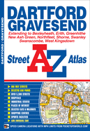
This street atlas of Dartford, Gravesend, Bexleyheath, Erith, Northfleet, Sidcup and Swanley features 30 pages of coloured mapping that extends to: Thamesmead East, Crayford, Stone, Greenhithe, Swanscombe, Tilbury (part), Shorne, Singlewell, Meopham Station, New Ash Green, West Kingsdown (part), Farningham, Crockenhill, Hextable, Ruxley, Blackfen and Welling. Postcode districts, one-way streets and safety camera locations with their maximum speed limit are featured on the mapping. The index section lists streets, selected flats, walkways and places of interest, junction, place, area and station names, hospitals and hospices covered by this atlas.
Read Less
Add this copy of Dartford Street Atlas to cart. $15.98, like new condition, Sold by GreatBookPrices rated 4.0 out of 5 stars, ships from Columbia, MD, UNITED STATES, published 2014 by Geographers' A-Z Map Co Ltd.
Choose your shipping method in Checkout. Costs may vary based on destination.
Seller's Description:
Geographers' A-Z Map Company. Fine. A-Z Street Atlas. Includes illustrations. In Stock. 100% Money Back Guarantee. Brand New, Perfect Condition, allow 4-14 business days for standard shipping. To Alaska, Hawaii, U.S. protectorate, P.O. box, and APO/FPO addresses allow 4-28 business days for Standard shipping. No expedited shipping. All orders placed with expedited shipping will be cancelled. Over 3, 000, 000 happy customers.
Add this copy of Dartford & Gravesend Street Atlas (a-Z Street Atlas) to cart. $15.99, very good condition, Sold by Brit Books rated 4.0 out of 5 stars, ships from Milton Keynes, BUCKINGHAMSHIRE, UNITED KINGDOM, published 2011 by Geographers A-Z Map Company.
Choose your shipping method in Checkout. Costs may vary based on destination.
Seller's Description:
Very good. Simply Brit welcome to our online used book store, where affordability meets great quality. Dive into a world of captivating reads without breaking the bank. We take pride in offering a wide selection of used books, from classics to hidden gems, ensuring there's something for every literary palate. All orders are shipped within 24 hours and our lightning fast-delivery within 48 hours coupled with our prompt customer service ensures a smooth journey from ordering to delivery. Discover the joy of reading with us, your trusted source for affordable books that do not compromise on quality.
Add this copy of Dartford & Gravesend Street Atlas (a-Z Street Atlas) to cart. $15.99, good condition, Sold by Brit Books rated 4.0 out of 5 stars, ships from Milton Keynes, BUCKINGHAMSHIRE, UNITED KINGDOM, published 2011 by Geographers A-Z Map Company.
Choose your shipping method in Checkout. Costs may vary based on destination.
Seller's Description:
Good. Simply Brit welcome to our online used book store, where affordability meets great quality. Dive into a world of captivating reads without breaking the bank. We take pride in offering a wide selection of used books, from classics to hidden gems, ensuring there's something for every literary palate. All orders are shipped within 24 hours and our lightning fast-delivery within 48 hours coupled with our prompt customer service ensures a smooth journey from ordering to delivery. Discover the joy of reading with us, your trusted source for affordable books that do not compromise on quality.
Add this copy of Dartford Street Atlas to cart. $16.22, new condition, Sold by GreatBookPrices rated 4.0 out of 5 stars, ships from Columbia, MD, UNITED STATES, published 2014 by Geographers' A-Z Map Co Ltd.
Choose your shipping method in Checkout. Costs may vary based on destination.
Seller's Description:
Geographers' A-Z Map Company. New. A-Z Street Atlas. Includes illustrations. In Stock. 100% Money Back Guarantee. Brand New, Perfect Condition, allow 4-14 business days for standard shipping. To Alaska, Hawaii, U.S. protectorate, P.O. box, and APO/FPO addresses allow 4-28 business days for Standard shipping. No expedited shipping. All orders placed with expedited shipping will be cancelled. Over 3, 000, 000 happy customers.
Add this copy of Dartford and Gravesend a-Z Street Atlas to cart. $16.23, new condition, Sold by Blackwell's rated 3.0 out of 5 stars, ships from Gloucester, GLOUCESTERSHIRE, UNITED KINGDOM, published 2014 by HarperCollins Publishers.