Road atlas, at A4 size, covering the whole of Ireland featuring clear and detailed Collins colour mapping at a scale of 5.2 miles to 1 inch. Perfect for both residents and visitors touring Ireland. Clear, detailed and up-to-date Collins mapping showing: * Places of tourist interest * Contact information for Tourist Information Centres with grid references to the mapping * Fully indexed street maps of 11 cities and towns - Dublin, Belfast, Cork, Limerick, Londonderry (Derry), Galway, Bangor, Waterford, Dun ...
Read More
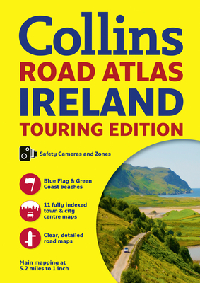
Road atlas, at A4 size, covering the whole of Ireland featuring clear and detailed Collins colour mapping at a scale of 5.2 miles to 1 inch. Perfect for both residents and visitors touring Ireland. Clear, detailed and up-to-date Collins mapping showing: * Places of tourist interest * Contact information for Tourist Information Centres with grid references to the mapping * Fully indexed street maps of 11 cities and towns - Dublin, Belfast, Cork, Limerick, Londonderry (Derry), Galway, Bangor, Waterford, Dun Laoghaire, Drogheda and Killarney * Speed enforcement zones and fixed location speed cameras * Blue Flag & Green Coast beaches * Ferry and airport information; Distance chart; Distances marked on the roads in miles and kilometres * Route planning map of the whole of Ireland at 15.8 miles to 1 inch * Administrative map of Irish counties and districts
Read Less
Add this copy of Collins Ireland Road Atlas: Touring Edition to cart. $64.97, new condition, Sold by Revaluation Books rated 4.0 out of 5 stars, ships from Exeter, DEVON, UNITED KINGDOM, published 2017 by Collins.