National Geographic's Trails Illustrated Maps are the most detailed and up-to-date topographic recreation maps available for US National Parks, National Forests and other popular outdoor recreation areas. A necessity for exploring the outdoors, each map is printed on waterproof, tear-resistant material. They also contain key safety and contact information, GPS and compass coordinates, Leave No Trace ethical guidelines and hundreds of points-of-interest, including scenic viewpoints, campgrounds, boat launches, swimming areas ...
Read More
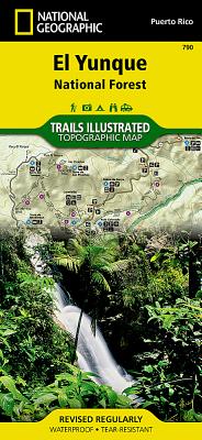
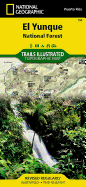
National Geographic's Trails Illustrated Maps are the most detailed and up-to-date topographic recreation maps available for US National Parks, National Forests and other popular outdoor recreation areas. A necessity for exploring the outdoors, each map is printed on waterproof, tear-resistant material. They also contain key safety and contact information, GPS and compass coordinates, Leave No Trace ethical guidelines and hundreds of points-of-interest, including scenic viewpoints, campgrounds, boat launches, swimming areas, marine sanctuaries and wildlife refuges.
Read Less
Add this copy of Caribbean National Forest to cart. $14.79, new condition, Sold by Ambis Enterprises LLC rated 3.0 out of 5 stars, ships from Benton Harbor, MI, UNITED STATES, published 2002 by National Geographic Maps.
Choose your shipping method in Checkout. Costs may vary based on destination.
Seller's Description:
New. Brand New! Not Overstocks or Low Quality Book Club Editions! Direct From the Publisher! We're a small town bookstore that loves books and loves it's customers! Buy from US! National Forest/BLM S.., Sheet 790. Illustrations.
Add this copy of Caribbean National Forest Trails Illustrated Map # 790 to cart. $25.68, new condition, Sold by Revaluation Books rated 4.0 out of 5 stars, ships from Exeter, DEVON, UNITED KINGDOM, published 2001 by Natl Geographic Society Maps.
Add this copy of El Yunque National Forest Trails Illustrated Other Rec to cart. $28.11, new condition, Sold by Paperbackshop rated 4.0 out of 5 stars, ships from Bensenville, IL, UNITED STATES, published 2012 by National Geographic Maps Division.
Add this copy of El Yunque National Forest Map (National Geographic to cart. $32.88, good condition, Sold by Bonita rated 4.0 out of 5 stars, ships from Newport Coast, CA, UNITED STATES, published 2020 by Natl Geographic Society Maps.
Add this copy of El Yunque National Forest Map (National Geographic to cart. $62.57, new condition, Sold by Bonita rated 4.0 out of 5 stars, ships from Newport Coast, CA, UNITED STATES, published 2020 by Natl Geographic Society Maps.
Add this copy of El Yunque National Forest Map (National Geographic to cart. $118.90, new condition, Sold by GridFreed rated 4.0 out of 5 stars, ships from North Las Vegas, NV, UNITED STATES, published 1969 by Natl Geographic Society Maps.