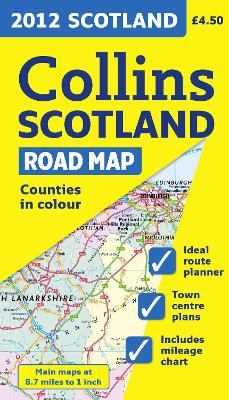
Full colour map of Scotland at 9 miles to 1 inch (1:550,000 approx.) with clear, detailed road network and administrative areas shown in colour. MAIN FEATURES This popular map has clear political colouring with administrative areas shown in colour. In addition to this it has 7 city/town centre street plans. INCLUDES * Mileage chart. * Key in English, French and German. AREA OF COVERAGE Covers the whole of Scotland and part of Northern England on a one-sided map. WHO THE PRODUCT IS OF ...
Read More
Full colour map of Scotland at 9 miles to 1 inch (1:550,000 approx.) with clear, detailed road network and administrative areas shown in colour. MAIN FEATURES This popular map has clear political colouring with administrative areas shown in colour. In addition to this it has 7 city/town centre street plans. INCLUDES * Mileage chart. * Key in English, French and German. AREA OF COVERAGE Covers the whole of Scotland and part of Northern England on a one-sided map. WHO THE PRODUCT IS OF INTEREST TO This is a general purpose map and is of interest to both business users and for those touring the country. It has a particular emphasis on political features and can be used as a reference map and a route planning map.
Read Less
Add this copy of 2012 Scotland Road Map (International Road Atlases) to cart. $38.78, good condition, Sold by Goldstone Books rated 4.0 out of 5 stars, ships from Ammanford, CARMS, UNITED KINGDOM, published 2011 by Collins.
Choose your shipping method in Checkout. Costs may vary based on destination.
Seller's Description:
Good. All orders are dispatched within 1 working day from our UK warehouse. Established in 2004, we are dedicated to recycling unwanted books on behalf of a number of UK charities who benefit from added revenue through the sale of their books plus huge savings in waste disposal. No quibble refund if not completely satisfied.