The image to the right shows a volcanic landscape in central Africa, including parts of Rwanda, Uganda, and the Democratic Republic of the Congo (formerly Zaire). This image was obtained from the SIR-C multi-wavelength radar remote sensing system, operated on the space shuttle Endeavor in 1994. SIR-C monitors the earth's surface using wave-lengths of energy that are much longer than the visible light seen by the human eye; thus, the hues in this "false colour" radar image have little to no relationship to what would be seen ...
Read More
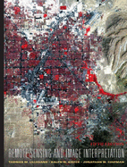
The image to the right shows a volcanic landscape in central Africa, including parts of Rwanda, Uganda, and the Democratic Republic of the Congo (formerly Zaire). This image was obtained from the SIR-C multi-wavelength radar remote sensing system, operated on the space shuttle Endeavor in 1994. SIR-C monitors the earth's surface using wave-lengths of energy that are much longer than the visible light seen by the human eye; thus, the hues in this "false colour" radar image have little to no relationship to what would be seen in ordinary visible light. The volcano at top center of the image is Karisimba, 4500 m high. The green patch on the lower slopes of Karisimba volcano, to the right of its peak, is an area of bamboo forest-one of the world's few remaining habitats for mountain gorillas. Only some 600-700 mountain gorillas still remain on earth. Because the SIR-C radar is virtually unaffected by weather conditions, it is an ideal tool for capturing images over the cloudy and misty volcanic areas where mountain gorillas live. Nyiragongo volcano (3465 m elevation) dominates the lower portion of the image some of the lava flows that surround it have a distinctive purple appearance in this image. As shown here, remote sensing in wavelengths of energy outside the range of visible light can often reveal aspects of our environment that complement what can be detected by the unaided eye. (This image covers a 24 km by 60 km area.) The global image (inset, below) is a composite view of vegetation cover on land and chlorophyll concentration in the oceans. This image was derived from data collected by the SeaWiFS global ocean colour monitoring mission. Wide field of view sensors such as SeaWiFS permit continuous, long term monitoring of the environment on a global scale, providing an important contribution to our understanding of the earth system as a single, integrated whole.
Read Less
Add this copy of Remote Sensing and Image Interpretation to cart. $3.23, very good condition, Sold by ThriftBooks-Atlanta rated 5.0 out of 5 stars, ships from Brownstown, MI, UNITED STATES, published 1999 by Wiley.
Add this copy of Remote Sensing and Image Interpretation to cart. $3.23, good condition, Sold by ThriftBooks-Atlanta rated 5.0 out of 5 stars, ships from Brownstown, MI, UNITED STATES, published 1999 by Wiley.
Add this copy of Remote Sensing and Image Interpretation to cart. $3.23, very good condition, Sold by ThriftBooks-Reno rated 4.0 out of 5 stars, ships from Reno, NV, UNITED STATES, published 1999 by Wiley.
Add this copy of Remote Sensing and Image Interpretation to cart. $3.23, good condition, Sold by ThriftBooks-Reno rated 4.0 out of 5 stars, ships from Reno, NV, UNITED STATES, published 1999 by Wiley.
Add this copy of Remote Sensing and Image Interpretation to cart. $3.23, good condition, Sold by ThriftBooks-Baltimore rated 4.0 out of 5 stars, ships from Halethorpe, MD, UNITED STATES, published 1999 by Wiley.
Add this copy of Remote Sensing and Image Interpretation, 3rd Edition to cart. $3.39, good condition, Sold by BookDepart rated 4.0 out of 5 stars, ships from Shepherdstown, WV, UNITED STATES, published 1994 by John Wiley and Sons.
Choose your shipping method in Checkout. Costs may vary based on destination.
Seller's Description:
UsedGood. Hardcover; 3rd edition; fading and shelf wear to exterior; corners bumped; rear hinge cracked and back board is slightly cocked; otherwise in good con dition with clean text.
Add this copy of Remote Sensing and Image Interpretation to cart. $3.68, fair condition, Sold by ThriftBooks-Reno rated 4.0 out of 5 stars, ships from Reno, NV, UNITED STATES, published 1979 by John Wiley & Sons.
Add this copy of Remote Sensing and Image Interpretation to cart. $3.68, fair condition, Sold by ThriftBooks-Baltimore rated 4.0 out of 5 stars, ships from Halethorpe, MD, UNITED STATES, published 1979 by John Wiley & Sons.
Add this copy of Remote Sensing and Image Interpretation, 2nd Edition to cart. $3.85, very good condition, Sold by BookDepart rated 4.0 out of 5 stars, ships from Shepherdstown, WV, UNITED STATES, published 1979 by Wiley.
Add this copy of Remote Sensing and Image Interpretation: 2nd Ed to cart. $4.00, good condition, Sold by HPB-Red rated 5.0 out of 5 stars, ships from Dallas, TX, UNITED STATES, published 1987 by John Wiley and Sons Ltd.
Choose your shipping method in Checkout. Costs may vary based on destination.
Seller's Description:
Good. Connecting readers with great books since 1972! Used textbooks may not include companion materials such as access codes, etc. May have some wear or writing/highlighting. We ship orders daily and Customer Service is our top priority!