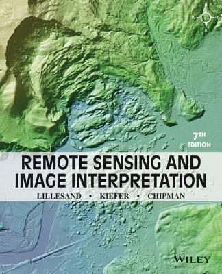
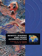
The image to the right shows a volcanic landscape in central Africa, including parts of Rwanda, Uganda, and the Democratic Republic of the Congo (formerly Zaire). This image was obtained from the SIR-C multi-wavelength radar remote sensing system, operated on the space shuttle Endeavor in 1994. SIR-C monitors the earth's surface using wave-lengths of energy that are much longer than the visible light seen by the human eye; thus, the hues in this "false colour" radar image have little to no relationship to what would be seen ...
Read More
The image to the right shows a volcanic landscape in central Africa, including parts of Rwanda, Uganda, and the Democratic Republic of the Congo (formerly Zaire). This image was obtained from the SIR-C multi-wavelength radar remote sensing system, operated on the space shuttle Endeavor in 1994. SIR-C monitors the earth's surface using wave-lengths of energy that are much longer than the visible light seen by the human eye; thus, the hues in this "false colour" radar image have little to no relationship to what would be seen in ordinary visible light. The volcano at top center of the image is Karisimba, 4500 m high. The green patch on the lower slopes of Karisimba volcano, to the right of its peak, is an area of bamboo forest-one of the world's few remaining habitats for mountain gorillas. Only some 600-700 mountain gorillas still remain on earth. Because the SIR-C radar is virtually unaffected by weather conditions, it is an ideal tool for capturing images over the cloudy and misty volcanic areas where mountain gorillas live. Nyiragongo volcano (3465 m elevation) dominates the lower portion of the image some of the lava flows that surround it have a distinctive purple appearance in this image. As shown here, remote sensing in wavelengths of energy outside the range of visible light can often reveal aspects of our environment that complement what can be detected by the unaided eye. (This image covers a 24 km by 60 km area.) The global image (inset, below) is a composite view of vegetation cover on land and chlorophyll concentration in the oceans. This image was derived from data collected by the SeaWiFS global ocean colour monitoring mission. Wide field of view sensors such as SeaWiFS permit continuous, long term monitoring of the environment on a global scale, providing an important contribution to our understanding of the earth system as a single, integrated whole.
Read Less