Navigate your way around London with this detailed, easy-to-use and up-to-date A-Z Street Atlas. First published in 1936, this iconic atlas is a trusted means of finding your way around the capital city. The main mapping extends beyond Central London from Heathrow Airport to Chingford at a scale of 2.88 inches to 1 mile (4.55 cm to 1 km), featuring postcode districts, one-way streets, the Congestion Charging Zone and Low Emission Zone. The large-scale street map of Central London - at a scale ...
Read More
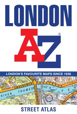
Navigate your way around London with this detailed, easy-to-use and up-to-date A-Z Street Atlas. First published in 1936, this iconic atlas is a trusted means of finding your way around the capital city. The main mapping extends beyond Central London from Heathrow Airport to Chingford at a scale of 2.88 inches to 1 mile (4.55 cm to 1 km), featuring postcode districts, one-way streets, the Congestion Charging Zone and Low Emission Zone. The large-scale street map of Central London - at a scale of 5.75 inches to 1 mile - cover Regent's Park and Shoreditch, Chelsea and Vauxhall, Hyde Park and Bermondsey. A comprehensive index lists streets, selected flats, walkways and places of interest, place, area and junction names. Additional healthcare (hospitals, walk-in centres and hospices) and transport connections (National Rail, London Tramlink, Docklands Light Railway, London Underground and Overground stations, and River Bus pier) are indexed as well. Also included are: * Overview map of the Congestion Charging Zone, Ultra Low Emission and Low Emission Zones * West End Theatre map * London Connections rail services map
Read Less
Add this copy of London Az Street Atlas to cart. $12.12, new condition, Sold by Paperbackshop rated 4.0 out of 5 stars, ships from Bensenville, IL, UNITED STATES, published 2020 by HarperCollins Publishers.
Add this copy of London A-Z Street Atlas to cart. $16.00, new condition, Sold by Ria Christie Books rated 5.0 out of 5 stars, ships from Uxbridge, MIDDLESEX, UNITED KINGDOM, published 2020 by HarperCollins.
Add this copy of London a-Z Street Atlas to cart. $18.90, new condition, Sold by Blackwell's rated 3.0 out of 5 stars, ships from Gloucester, GLOUCESTERSHIRE, UNITED KINGDOM, published 2020 by HarperCollins Publishers.
Add this copy of London a-Z Street Atlas to cart. $19.34, new condition, Sold by Revaluation Books rated 4.0 out of 5 stars, ships from Exeter, DEVON, UNITED KINGDOM, published 2020 by Harpercollins Publishers.
Add this copy of London A-Z Street Atlas to cart. $19.46, new condition, Sold by Booksplease rated 4.0 out of 5 stars, ships from Southport, MERSEYSIDE, UNITED KINGDOM, published 2020 by HarperCollins.
Add this copy of London a-Z Street Atlas to cart. $21.08, new condition, Sold by Kennys.ie rated 4.0 out of 5 stars, ships from Galway, IRELAND, published 2020 by HarperCollins.